


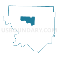
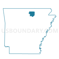
BROCKWELL Voting District, Izard County, Arkansas
About
Outline

Summary
| Unique Area Identifier | 526732 |
| Name | BROCKWELL Voting District |
| County | Izard County |
| State | Arkansas |
| Area (square miles) | 26.95 |
| Land Area (square miles) | 26.95 |
| Water Area (square miles) | 0.00 |
| % of Land Area | 100.00 |
| % of Water Area | 0.00 |
| Latitude of the Internal Point | 36.14224730 |
| Longtitude of the Internal Point | -91.95144660 |
Maps

Graphs
Select a template below for downloading or customizing gragh for BROCKWELL Voting District, Izard County, Arkansas


Neighbors
Neighoring Voting District (by Name) Neighboring Voting District on the Map
- CALICO ROCK RURAL Voting District, Izard County, AR
- LARKIN Voting District, Izard County, AR
- MELBOURNE RURAL Voting District, Izard County, AR
- MELBOURNE WARD 2, Izard County, AR
- NEWBURG Voting District, Izard County, AR
- OXFORD RURAL Voting District, Izard County, AR
- OXFORD WARD 3, Izard County, AR
- OXFORD WARD 4, Izard County, AR
- PINEVILLE RURAL Voting District, Izard County, AR
- VIOLET HILL Voting District, Izard County, AR
- WIDEMAN Voting District, Izard County, AR
Top 10 Neighboring County Subdivision (by Population) Neighboring County Subdivision on the Map
- Union township, Izard County, AR (2,448)
- Mill Creek township, Izard County, AR (2,173)
- New Hope township, Izard County, AR (956)
- Newburg township, Izard County, AR (712)
- Violet Hill township, Izard County, AR (350)
- Lacrosse township, Izard County, AR (323)
- Guthrie township, Izard County, AR (109)
Top 10 Neighboring Place (by Population) Neighboring Place on the Map
Top 10 Neighboring Unified School District (by Population) Neighboring Unified School District on the Map
- Melbourne School District, AR (5,339)
- Izard Cty Consolidated Schools, AR (4,831)
- Calico Rock School District, AR (3,587)